
Mongar Dzongkhag (District) is about 460 km east of Thimphu, the capital city of Bhutan. It lies between 27.25 ̊ latitude and 91.2 ̊ longitude. It has an area of about 1,940.26 sq.km with elevation ranging from 400-4000 meters above sea level. The lower and the southern parts are subtropical while northern regions have temperate climate. Summer can be hot and humid while winter is cold.
The District is enclaved by six Districts viz. Bumthang, Lhuentse, Trashigang, Pema Gatshel, Samdrup Jongkhar and Zhemgang Districts. The rivers of Kuri-Chhu, Sheri-Chhu and Drangme-Chhu flows through the scenic valleys of the Dzongkhag.
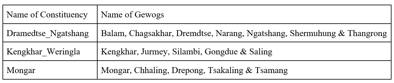
The Dzongkhag is divided into 17 Gewogs (Blocks), 88 Chiwogs (Sub division of blocks) and about 720 Villages, and three Constituencies (Demkhong) viz (i) Dramedtse - Ngatshang, (ii) Kengkhar - Weringla and (iii) Mongar Demkhongs for the election purpose.
Details of Demkhongs and gewogs
The total population of Mongar Dzongkhag, as per PHCB 2017 projection for 2022 is 36383 with 17,498 Male and 18,886 Female, total of 10,084 residing in urban centres of Mongar, Gyalpoizhing, Lingmithang, Kidheykhar, Drametse and Yadi towns and with the rural population of 26,299 residing in 17 Gewogs.
Citrus fruits and vegetables, dairy and poultry products are increasingly becoming important sources of cash income. Mongar Dzongkhag is popular for beaten maize (Tengma) with abundant supply from Chhaling and Saling gewogs.
The District has the following infrastructure as of 2022;
41 numbers of Schools (7 extended class rooms, 24 Primary Schools, 5 Middle Secondary Schools, 5 Higher Secondary Schools with a total of about 8830 students and 611 teachers).
1 Regional Referral Hospital and a 10 bedded hospital, 22 Primary Health Centres, 5 Sub Posts and 52 Outreach Clinics.
17 Renewable Natural Resources Extension Centers, 1 Agriculture Research and Development Centers located at Wengkhar and a sub center at Lingmithang.
All the Gewogs (blocks) are connected with black topped roads of about 364.85km, further covering the villages with farm roads of about 1413.11km, and forest roads of 37km. There are about a total of 30 numbers of motorable bridges and 10 numbers of non motorable bridges. Every household is connected with electricity, mobile networks, has access to safe drinking water and facilitated with irrigation channels in few areas.
The Mongar District being centrally located in the eastern region of Bhutan, with numerous cultural sites and Sacred Nye is seeing a potential boost in economic growth. District hosts a number of regional offices and a Mongar Regional Hospital, besides providing medical services, plays an important role in retaining the local population and boosting the local economy.
The District is likely to gain more populations after the establishment of Mother Child care unit, Gyalsung project, Pongchela airport, Kaja Throm (town) expansion of urban centres from Gyaploshing to Yadi through Mongar Town.